Through our integration with Autodesk, designers can easily see below the ground to build on solid ground
Understanding subsurface conditions is essential for civil engineers and designers to develop safe, efficient structures. Yet integrating geotechnical data into design workflows has traditionally been a complex challenge.
Bridge the gap between geotechnical data and design processes
Chances are high that you're probably struggling with a familiar problem: critical ground data sits isolated from your Civil 3D designs. Over 50% of organizations face this exact challenge, leading to costly over-engineering, unexpected redesigns, and project delays when ground conditions don't match expectations.
An alternative to the Geotechnical Modeler
GeoDin Ground is a powerful solution that serves as a modern replacement for the Geotechnical Modeler for Civil 3D. While many professionals have relied on the Geotechnical Modeler to import and visualize subsurface data in Civil 3D, GeoDin Ground delivers enhanced capabilities and a more intuitive experience.
What makes GeoDin Ground unprecedented?
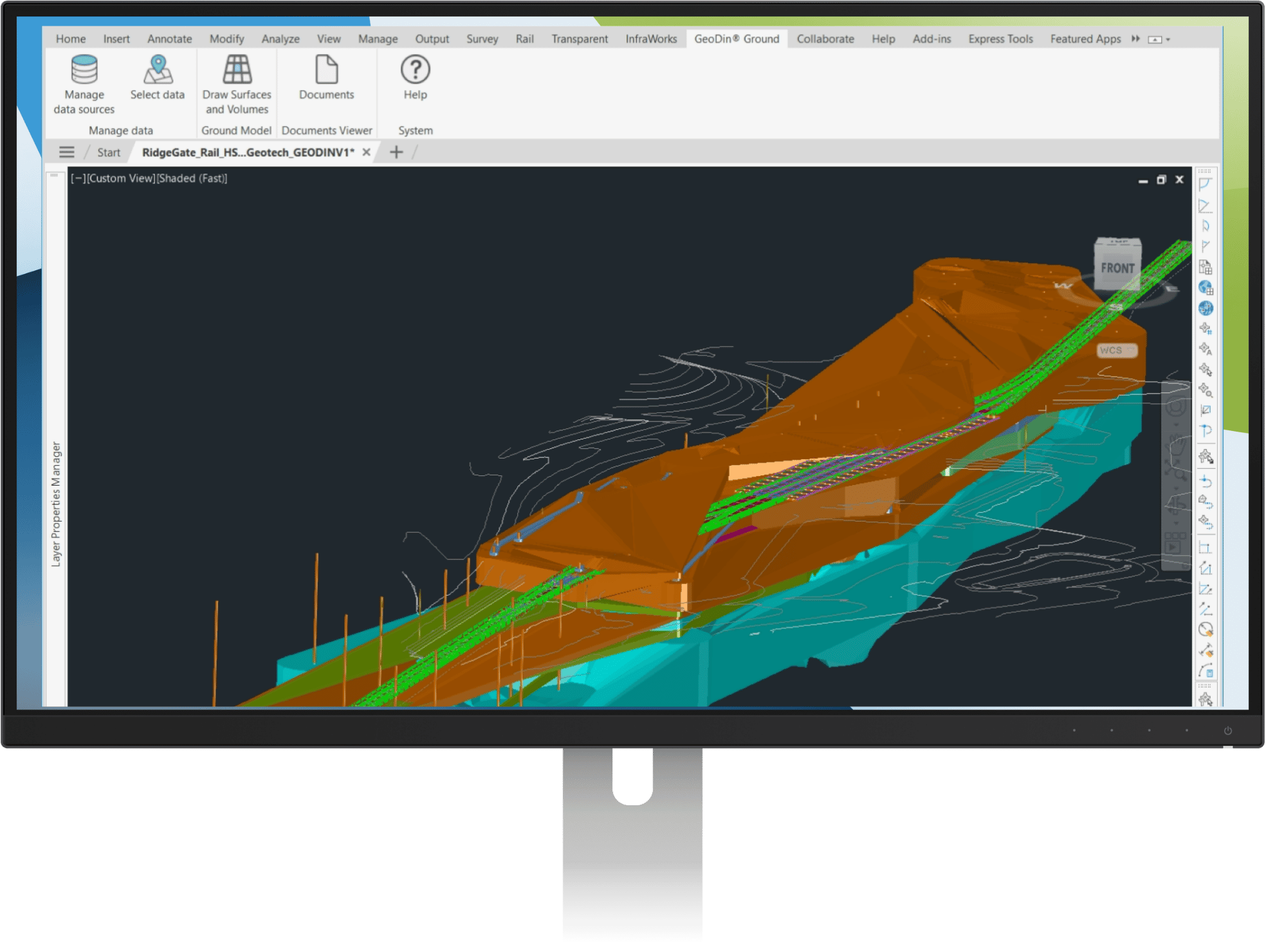
While the traditional Geotechnical Modeler helped import basic ground data, GeoDin Ground transforms how you work with subsurface information. Get instant access to comprehensive drilling data, cone penetration test results, and automated compliance with local regulations - all within your familiar Civil 3D environment.
Experience advanced 3D borehole modelling capabilities that bring your subsurface data to life with unprecedented detail and accuracy.
Differences between GeoDin Ground and Civil 3D Geotechnical Modeler
How does GeoDin Ground compare to the Geotechnical Modeler for Civil 3D? This overview provides you with key differences on data import & management, visualizations, reporting & customization, workflow and updates.
Data Import
Direct connection to GeoDin geotechnical database, ensuring secure access to the latest data, ability to select in real-time from multiple databases, projects, locations.
Manual import of basic geotech data for boreholes (AGS or CSV), issues due to asynchronous.
Data Management
Data available for calculations, analysis & filtering by Civil 3D (by e.g., property sets functionalities).
Lack of ability to leverage the advanced capabilities of Civil 3D.
Data Updates
Ability to control incremental ingest data updates directly from database to ensure latest data (expected mid 2025).
Requires manual re-ingest of data.
Supported Datatypes
Various geotechnical parameters (layer description, thickness) as well as full borehole logs.
Only location, depth, and lithology.
Reporting
Ability to leverage the power of GeoDin for advanced reporting. Generate reports by exports of borehole logs, cross-sections (expected mid-2025).
No reporting capabilities.
Visualization in Civil 3D
Render 3D boreholes, layers, and surfaces, with customizations on visualizations by layers (e.g., custom colors based on lithology). Detailed rendered borehole logs (expected early 2025).
Render 3D boreholes, layers, and surfaces.
What's ahead
GeoDin Ground is just the first step towards tight collaboration between design and ground and improved engineering workflows. We have a dedicated team working on further enriching the interoperability between GeoDin and Civil 3D. They are currently working on:
- Ingestion of more geotech data types
- Establish a two-way connection
- Embed geophysics in the design
Please contact our team if you have any specific wishes or ideas, we'd love to hear from you.
Ready to transform your 3D borehole modelling process?
GeoDin Ground isn't just an upgrade - it's your competitive advantage in delivering safer, more efficient projects through advanced 3D borehole modelling capabilities. Join the engineering firms already transforming their workflows with this powerful Autodesk integration
BUILD ON SOLID GROUND™
Today with GeoDin®
Your cart
Taxes will be calculated at checkout