
Lorem Ipsum dolor
Customer
Test
Location
Amsterdam
Summary
Reducing Project Delivery Time at Fugro Brazil
In early 2024, Fugro Brazil's geotechnical investigation department faced a critical challenge: their average project delivery time stretched to 41 days from field completion to client delivery. As Luana Barbosa, Supervisor of the Reports Team, recalls: "We didn't have a metric before of how long it took us from finalizing the field work until it reached the client's hands."
GeoDin implementation impact in numbers
0
%
Reduction in delivery time
0
days
Days saved per project

The challenge
Reducing Project Delivery Time at Fugro Brazil
In early 2024, Fugro Brazil's geotechnical investigation department faced a critical challenge: their average project delivery time stretched to 41 days from field completion to client delivery. As Luana Barbosa, Supervisor of the Reports Team, recalls: "We didn't have a metric before of how long it took us from finalizing the field work until it reached the client's hands."
The root cause? A fragmented workflow that created a cascade of inefficiencies such as:
- Manual data processing leading to time-consuming transfer and validation of field information
- Calculation bottlenecks due to manual computation of CPT values, recovery rates, and geological analyses
- Inconsistent reporting since each report required extensive manual formatting and customization
- Quality control delays due to errors discovered late in the process required revisiting already-completed work
- Communication gaps leading to endless iterations to achieve the right report format for clients
For a team committed to continuous improvement based on a DMAIC methodology, the situations was clear; without reliable data management and processing tools, optimization was impossible.
The Solution
GeoDin as the central hub for geotechnical data management
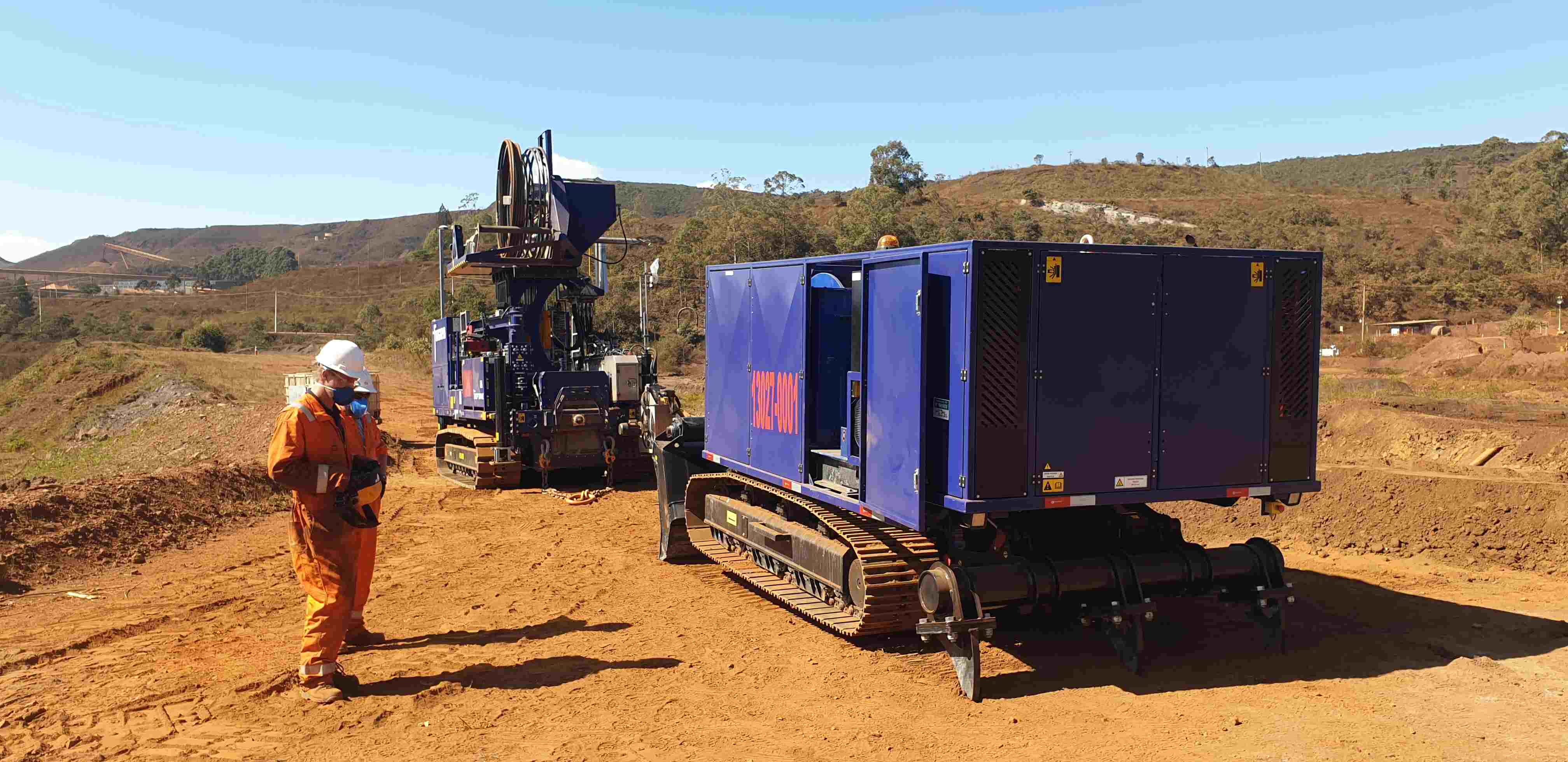
Fugro Brazil recognized that true transformation required a comprehensive platform that could handle the entire data lifecycle - from ingestion to final reporting. Their answer was GeoDin, the geotechnical data management platform designed specifically for the complexities of soil investigation and reporting.
To maximize field efficiency, they paired GeoDin with GeoDin Onsite for digital field capture, creating an end-to-end solution where GeoDin serves as the central intelligence hub. (Summary of the solution)
The Result
83% faster delivery, zero compromise on quality
- 83% reduction in delivery time: From 41 days to 7 days (and continuing to improve toward a 5-day target)
- Dramatic improvement in data processing efficiency: Automated calculations and intelligent data management eliminated days of manual work
- Significant cost savings: Reduced financial waste through elimination of rework and manual processing
- Consistent quality and compliance: Automated standards-based calculations ensured every report met Brazilian requiremnts (Sumary of the results)
Request consulting services
Besides our software, you can also request consulting services from our GeoDin® consultants. We are very happy to train your team, discuss use cases and to help you get the most out of GeoDin®.
The solution
GeoDin as the central hub for geotechnical data management
Fugro Brazil recognized that true transformation required a comprehensive platform that could handle the entire data lifecycle - from ingestion to final reporting. Their answer was GeoDin, the geotechnical data management platform designed specifically for the complexities of soil investigation and reporting.
To maximize field efficiency, they paired GeoDin with GeoDin Onsite for digital field capture, creating an end-to-end solution where GeoDin serves as the central intelligence hub. (Summary of the solution)
Turning field files into actionable geotechnical data with GeoDin Onsite and GeoDin
Once data arrived from the field, GeoDin became the command centre for all processing and analysis. This is where the data management software's power becomes evident: data flows seamlessly from GeoDin Onsite into GeoDin, where accurate geotechnical data management takes over.
“GeoDin is an ideal combination of client-server software with all the advantages of a typical multi-user database solution and a high-specialized software for our subject matter experts.”

GeoDin transforms Fugro’s geotechnical workflow
GeoDin enabled the project team to process geotechnical data faster, ensure standards compliance automatically, and deliver client-ready reports in a fraction of the time - all while maintaining the flexibility to adapt to project-specific requirements. The implementation of GeoDin was crucial for the team for these five reasons:
Intuitive data organization
"It has filters like Excel, we can sort or filter in some way [...] you can play around like in Excel," says Luana. This made data verification quick and intuitive enabling teams to:
- this
- that
- everything
Turning field files into actionable geotechnical data with GeoDin Onsite and GeoDin
Once data arrived from the field, GeoDin became the command centre for all processing and analysis. This is where the data management software's power becomes evident: data flows seamlessly from GeoDin Onsite into GeoDin, where accurate geotechnical data management takes over.
“GeoDin is an ideal combination of client-server software with all the advantages of a typical multi-user database solution and a high-specialized software for our subject matter experts.”
Intuitive data organization
"It has filters like Excel, we can sort or filter in some way [...] you can play around like in Excel," says Luana. This made data verification quick and intuitive enabling teams to:
- this
- that
- everything
Turning field files into actionable geotechnical data with GeoDin Onsite and GeoDin
Once data arrived from the field, GeoDin became the command centre for all processing and analysis. This is where the data management software's power becomes evident: data flows seamlessly from GeoDin Onsite into GeoDin, where accurate geotechnical data management takes over.
GeoDin transforms Fugro’s geotechnical workflow
GeoDin enabled the project team to process geotechnical data faster, ensure standards compliance automatically, and deliver client-ready reports in a fraction of the time - all while maintaining the flexibility to adapt to project-specific requirements. The implementation of GeoDin was crucial for the team for these five reasons:

The solution
GeoDin as the central hub for geotechnical data management
Fugro Brazil recognized that true transformation required a comprehensive platform that could handle the entire data lifecycle - from ingestion to final reporting. Their answer was GeoDin, the geotechnical data management platform designed specifically for the complexities of soil investigation and reporting.
To maximize field efficiency, they paired GeoDin with GeoDin Onsite for digital field capture, creating an end-to-end solution where GeoDin serves as the central intelligence hub. (Summary of the solution)
Turning field files into actionable geotechnical data with GeoDin Onsite and GeoDin
Once data arrived from the field, GeoDin became the command centre for all processing and analysis. This is where the data management software's power becomes evident: data flows seamlessly from GeoDin Onsite into GeoDin, where accurate geotechnical data management takes over.
“GeoDin is an ideal combination of client-server software with all the advantages of a typical multi-user database solution and a high-specialized software for our subject matter experts.”
The solution
GeoDin as the central hub for geotechnical data management
Fugro Brazil recognized that true transformation required a comprehensive platform that could handle the entire data lifecycle - from ingestion to final reporting. Their answer was GeoDin, the geotechnical data management platform designed specifically for the complexities of soil investigation and reporting.
To maximize field efficiency, they paired GeoDin with GeoDin Onsite for digital field capture, creating an end-to-end solution where GeoDin serves as the central intelligence hub. (Summary of the solution)
Turning field files into actionable geotechnical data with GeoDin Onsite and GeoDin
Once data arrived from the field, GeoDin became the command centre for all processing and analysis. This is where the data management software's power becomes evident: data flows seamlessly from GeoDin Onsite into GeoDin, where accurate geotechnical data management takes over.
BUILD ON SOLID GROUND™
Today with GeoDin®
Try GeoDin for 30 days and see if it holds up to OpenGround. Contact us on how to migrate from OpenGround to GeoDin - we'll be expecting your call.
Your cart
Taxes will be calculated at checkout